Friday, August 31, 2012

Where the wind comes sweeping down the plain...

Oklahoma City, OK

Lots of driving today, but some interesting spots. First place was Santa Rosa, NM, which contains a fragment of old Rte.66. As you probably know, Rte. 66 largely disappeared when I-40 was built, but it still contains some old 50s motels and abandoned 50s gas stations, some of which are now nostalgic gift shops.

We then headed east on I-40 and stopped in Tucumcari, NM, which also has some Rte. 66. We stopped at the Blue Swallow Motel, which advertises "refrigerated air." The place was charming and fixed up nicely. A couple of 50s cars in the front, and some of those old metal patio chairs painted bright colors. This place had garages for guests and they're now painted with scenes from "Easy Rider" and other Western scenes. We talked to the owners, who bought the place last year and fixed it up. They both lost their jobs in Michigan last year and bought the motel to try to make a fresh start. They seem to be doing well so far. They sell out every night.

After that we drove down the street to have a bite at Dell's, another old place that seems to be doing well. I had a hamburger that was so big I could hardly get it in my mouth.

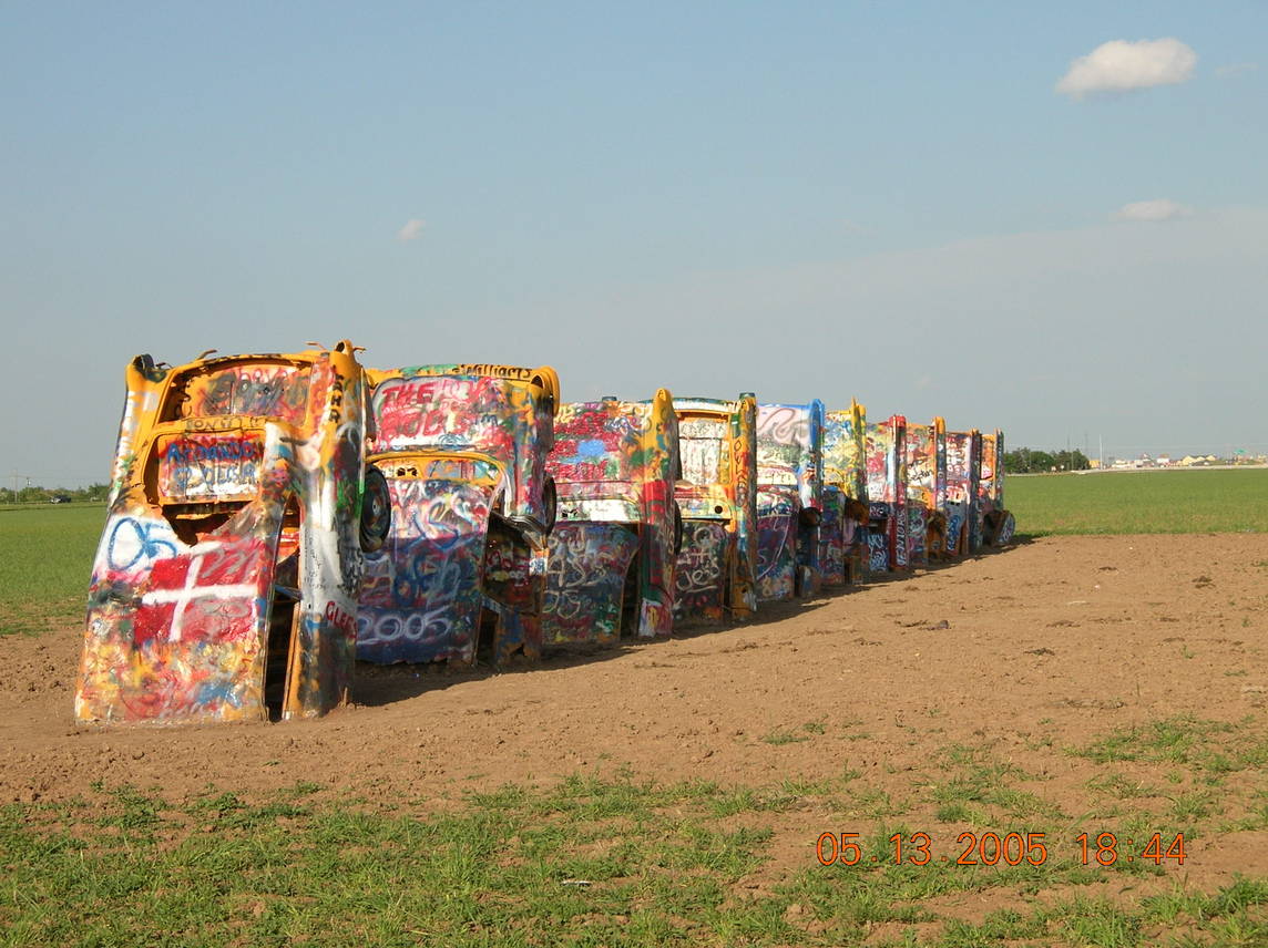
Along I-40 in Amarillo, Texas, we stopped at the Cadillac Ranch, an unusual (to say the least) roadside attraction. In the 70s, a rich Texan, working in concert with some San Francisco hippie artists, planted 10 Cadillacs along the roadside. The noses are stuck in the ground in a straight row at an angle that's supposed to mimic one of the Pyramids. The site is open to the public and for years people have been taking parts and spray painting graffiti on the cars. There were a bunch of people doing that while we were there. They cover up other stuff and do their own thing. Tomorrow, others will come and do the same thing. The paint must be an inch thick, at least. The only disconcerting thing is that lots of people simply discard their empty cans on the ground. It's a mess.

The scenery has changed a lot since we left NM this morning. Lots of mesas and such when we headed out of NM, then endless expanses of range land in Texas. I expected Oklahoma to be the same, but it's not. It's become hilly and green where we are. Kind of nice after all that desert.

Add caption
Tomorrow we'll explore Oklahoma City a bit and then head for Little Rock, Arkansas.

Thursday, August 30, 2012

What happens in Vegas is...nothing!

Las Vegas, New Mexico

We started the day by traveling to the small town of Montezuma to see the Montezuma Castle, built in the 1880s by the Santa Fe Railroad as a retreat. It's now the Armand Hammer United World College. The college is closed to the public, but we were there on the edge of it, and it appears to be populated by mostly foreign students. On the edge of the property, and open to the public, are hot springs. We stuck our feet in (they're really hot), and talked to the locals soaking in them.

Then we drove to the Salman Ranch in the historic town of La Cueva to buy some raspberries. La Cueva was founded in the 1830s. By 1850 La Cueva was a major shipping center for livestock and agricultural products, but that pretty much ended by the late 1880s. In 1942 the area was bought by Col William Salman, who restored some of the original adobe buildings, The town is now basically a raspberry farm. We went into the store to buy some raspberries and found the lady operating the store to be the most unfriendly people we've met on this trip. Probably the only unfriendly person we've met. She just would not allow herself to be drawn into conversation by any of her customers. Small-talk questions like , "Does it snow much here?" were met by "No." People like that shouldn't work with the public.

We spent the rest of the day exploring historic oldtown Las Vegas. The town was built in the 1850s and is full of the beautiful buildings that were built in the southwest of the time. It was very successful until the Great Depression killed it. It's still attractive, but half of the stores are empty, and a lot of the others seem to be closed much of the time. It's sad. Last year Michael and I took a road trip along the Mississippi River and encountered small towns just like Las Vegas -- barely holding on.

Nevertheless, it was fun wandering around the town, We went into a store selling western wear and it was stocked with thousands of cowboy boots and jeans, plus coats and shirts, and belts. Though we were the only "customers," the owner said he'd been there for 50 years and had customers from all over the southwest.

The picture accompanying this blog served as the jail in "Easy Rider."

As I write this listening to Romney's acceptance speech, I'm reminded that one of the best things about this trip is not having to read and listen to many campaign ads.

Tomorrow, on towards Amarillo, Texas, and parts east.


Wednesday, August 29, 2012

Not that Las Vegas

Las Vegas, New Mexico

Before leaving Canon City this morning we went to see the old historic downtown and saw a board on a building that listed the name and brand of the ranches in the area. It was begun in the 1850s and is still updated as necessary. Cute town, but just about everything was closed at the time we were there.

Later we stopped in Trinidad, Colorado, a town on the old Santa Fe Trail. Took a ride on a sightseeing trolley driven by a retired Greyhound Bus driver. Almost everything in Trinidad is made the red bricks--the streets, many buildings and residences, etc. The driver said no other place in the country uses as much brick per capita as Trinidad. (Who calculates this kind of stuff?)  Anyway, Trinidad was settled by Italian and German immigrants. The Italians did the stonework, including fancy carvings on the larger buildings, and the Germans did the interior woodwork, according to the driver.

Trinidad has the oldest, continuously operating reformed Jewish temple in the country (according to the driver). There used to be a lot of Jews in Trinidad, and they were very successful, said the driver, but they began moving out when competitors began eating into their profits. So they eventually all left and now they're in Venice, California. They'll never come back to Trinidad; no reason to come. The driver said all this without a hint of prejudice in his voice. Thankfully, there were no Jews on the trolley.

Oh, and so the temple continues to "operate continuously," I guess, because it was never sold and is still owned by the Jews. A rabbi in California has the only key to the building, but there's no reason for him to open the building because there are no Jews there.  Then, on another subject, he told us there were no bats in Colorado, just New Mexico. Old people, yikes!

A cute little town with lots of interesting restaurants. I had a Big Mac; Serry had an apple.

As we continued south on I-25, the land began changing. There are still mountains, mesas, and other  large rock outcroppings to be seen, but now they're far in the distance. The dominant feature in northern New Mexico so far are immense ranches.

We're in Las Vegas, NM, tonight and tomorrow night we'll explore the town tomorrow, as there's a lot of stuff to see according to Fodors, and then Friday we'll head toward Amarillo, Texas.

OOPS!

Delicate Arch
Canon City (pronounced canyon), Colorado

I wrote a nice long two-day blog last night, but then I made a bad keystroke and lost it. (It's somewhere, but I can't find it.) So, before I forget everything, here's an abbreviated version.

Monday, Arches NP, Utah. Disaster! Cell phone won't work! How text every couple of minutes, how send pics, how behave like other teenage girls? Crappy phone! Rotten AT&T! We'll have to go home! But wait. Think. When you hike in the desert with your cell phone in your bra because you sewed up your pockets to present a smooth appearance, maybe the phone got wet! Take it apart, dry the insides, eureka! it works, Life goes on. There is a god. Back to texting...

Arches is amazing. Lots of huge stone arches carved over (lots of ) time by rain, etc. Balance Rock. Picture a 350 ton egg balanced on a steeple of rock. Unbelievable! We hiked to famous Delicate Arch, the unofficial symbol of Utah. You've seen pictures. From pics I've seen I assumed it on the flat desert surface. You parked your car, took a short stroll, and there it was. Wrong. You park and then climb straight up for a half mile. Whew! But worth the considerable effort. Hot. When we returned to the parking area the temp. was a brisk 112 degrees.

Leaving Arches on scenic drive along Colorado River. Looking up, instead of down, at the cliffs. Like one of those movies watching people rafting in Grand Canyon. Can't adequately describe.

Overnight in Grand Junction, Colorado. Nice largish city. Then on to the Black Canyon of the Gunnison National Park on Tuesday. Spectacular! (There's that word again.) Unlike softer sandstone  parks we've been in in Utah, this place is made of hard, metamorphic stone, like Rocky Mountains.
Very deep and steep. About 1800 feet deep at visitor center, and maybe 80 feet wide at bottom. Canyon formed by Gunnison River rather than the weather. Really something. Had a short, level hike. Can't go down; never get back up.

Now in Canon City. Will explore historic area, and then head for Las  Vegas, New Mexico.

Sunday, August 26, 2012

Canyonlands National Park

Moab, Utah

We toured and hiked Canyonlands NP today. When we arrived at the visitors station, I mentioned to the park ranger that I was writing a blog each night about the parks we were visiting, and that I was having a hard time describing them. She said she knew exactly what I meant. All the parks contain fascinating, spectacular mesas, buttes, rock formations, canyons, etc. Each one is very different from the others, but they're very difficult to describe in words. It's like trying to describe how two women, who don't resemble each other, are nevertheless both beautiful. You simply have to see the parks to appreciate their grandeur.

Almost forgot. Yesterday, while hiking in Capitol Reef, we came across a female Bighorn Sheep with a broken rear leg. She had a kid with her, and she seemed to get along pretty well, but I don't suppose she'll last very long in that condition. Eventually, a mountain lion or something will get her.

Utahans seem pretty health-conscious--lots of mountain biking and other outdoor sports. So it's surprising to me the amount of food the restaurants serve. The other day in Escalante I had  1/3 lb cheeseburger (all the  hamburgers out here are 1/3 pounders), and French fries for about $8. I could barely get my mouth around the burger. That night, not very hungry, I ordered a burrito that turned out to be the size of a football. Last night I had a Caesar salad wrap. Another football!

Tomorrow: Arches National Park.

Saturday, August 25, 2012

Orchards in the Desert

The Castle, Capitol Reef NP
Moab, Utah

Apparently, each night while we're asleep, someone breaks into the car and litters it with brochures, napkins, seeds, mud, receipts, and other debris. Mice may even be living in it! If these vandals don't clean it up, I guess we'll have to do it...eventually.

We toured Capitol Reef NP today. It got its name from early Mormon settlers who were reminded by the immense cliffs and mesas of  reefs that hinder the passage of ships. 

The cliffs and mesas we've seen defy my ability to describe. The scenery is simply amazing. The best I can do is say it reminds me of those old epic cowboy movies that used to be so popular. The parks we visited in 2010 tended to be very large, with numerous attractions that were relatively easy to describe. Yellowstone, for instance, has Old Faithful, the mud pots, the Grand Canyon of the Yellowstone, buffalo herds, etc., each a distinct feature. Utah's canyon parks, on the other hand, are pretty much about one thing: their unusual geologic formations, e.g., Bryce's hoodoos. 

Nevertheless, Capitol Reef does have one additional attraction. Because the Sulfur and Freemont Rivers meet there and allow irrigation, early settlers developed orchards in a town now called Fruita. Serry and I picked apples. In the desert!

After the park, we drove on UT 24 toward Moab. UT 24 is designated as a Scenic Byway, and it certainly lives up to its name. Endless vistas of mountains, mesas, plateaus, canyons. As Serry noted, just when you think you've seen the most amazing scenery possibe, you go around a curve and it gets better.

Tonight and tomorrow night we're spending in Moab, a hip, trendy town in the middle of the desert. It gives easy access to both Canyonlands and Arches National Parks, so it's a destination for tourists. Lots of restaurants, touristy clothing stores, etc.

Tomorrow Canyonlands NP.


Friday, August 24, 2012

Greetings From Dale and Roy

Bryce Canyon Hoodoos
Torrey, Utah -- just outside of Capitol Reef National Park

Yesterday, Thursday, we spent at Bryce Canyon National Park. Spectacular! The park exists because of its hoodoos. Hoodoos are sandstone spires that were caused by the erosion of the surrounding land. They are massive, weirdly shaped things that I don't have the words to describe adequately. We took several hikes in the park,including one to the canyon floor that I'm still catching my breath from. Walking down is so much easier than up. At night we attended an astronomy lecture given by a park ranger. After the talk they set up telescopes so we could see the night sky (which is so black you can't believe it!), but it was getting too late so we bypassed the viewing. We had to get some sleep for our horseback excursion on Friday.

We last rode horses more than 20 years ago in West Virginia. We rode on a generally flat trail through the forest, and it was a lot of fun. Today's ride was completely different. Instead of a flat path we climbed steep trails in Red Canyon (near Bryce). I felt like I was in a cowboy movie escaping from a posse. In fact, Red Canyon is where Butch Cassidy hung out when the law was after him. We climbed up the canyon and then down. Very steep and rocky. It's a wonder the horses don't fall. A great time.

After that we headed toward Capitol Reef NP on scenic Rt. 12 through Grand Staircase-Escalante National Monument, a 1.6 million acre area that, through a series of increasingly raised plateaus links the canyonland parks in Utah with the Grand Canyon in Arizona. This is one of the wildest areas in the lower 48 states, and contains the last areas to be mapped in the lower 48. From the various scenic overlooks you look out on an unending vista of mesas and canyons. Breathtaking.

Tomorrow we explore Capitol Reef. The scenery is already breathtaking near our motel--huge red mesas and unusual rock formations. (I need to  get myself a thesaurus. I'm running out of adjectives to describe this stuff.)

Almost forgot. Hiking in Zion we came across three young Fundamentalist Latter Day Saints (FLDS) women and their children. FLDS women are easily identified my the identical long dresses they wear
as well as their unusual hair style. If you watched "Big Love" on HBO you know what I mean. FLDS are into polygamy, and I'm pretty sure these were sister-wives.


Wednesday, August 22, 2012

Zion National Park

Bryce, Utah--just outside of Bryce Canyon National Park

During our 2-month GART two years ago, it rained twice: once on the Florida panhandle, and once in Missoula, MT. This trip it's rained at least a little every day, including this morning. It turns out late summer is considered the monsoon season in southern Utah and northern Colorado. Who knew? But no problem. It wasn't raining too hard to enjoy Zion, and, in fact, the rain gives the canyon a look it doesn't have in the sunlight. And it stopped raining by noon.

Zion is beautiful.  Multicolored limestone cliffs tower over the canyon. Because of the recent rainstorms, numerous small (at this point) waterfalls have developed. They'll mostly dry up when the rainy season ends, but for now they provide extra interest to the park. Not that it need it.

As you probably know, heavy rain in the desert presents the risk of dangerous flash floods. The Virgin River runs through the canyon, and it's usually so shallow and slow-running that park visitors are invited to wade in it to get to trails on the opposite shore. Not today. Now there are signs warning people to stay out of the river. Of course, the signs are largely ignored. Someone will have to drown first.

On a hike up the mountains to see the Lower, Middle, and Upper Emerald Pools (aren't emeralds supposed to be green?), we were able to walk behind a couple of waterfalls. Neat! Also, I saw a guy who was obviously way too cool to wear one of those caps with a back part that shields your neck from the sun. I admit they're kind of funny looking. So this guy was wearing two baseball hats -- one forward and one backwards. I'm not sure it's really a better look.

On our way out of Zion we drove through a narrow mile-long tunnel built during the depression. It's so narrow that it can't accommodate a car going in one direction and a good-sized motor home going in the other. They have to close the tunnel to opposing traffic when a motor home needs to go through. Fortunately for us, what with school starting now, there aren't many motor homes on the road. The traffic tie ups at the tunnel must be terrible in the heart of summer.

On the other side of the tunnel the canyon looks very different. Instead of massive vertical rock formations, these formations, though just as large, look like horizontal layers put on top of one another by a baker wielding an icing knife. Stunning.

Tonight and tomorrow night we're staying in an old fashioned motel cabin a few miles from Bryce NP. Our front window looks out on mountains and grazing horses. Nice.

Tomorrow: Bryce Canyon NP.

Tuesday, August 21, 2012

Cowboys and Indians Country

Antelope Island
Springdale, Utah -- Just outside of Zion National Park

After leaving Salt Lake City this morning, we headed about 35 miles north to Antelope Island State Park, a large island in the Great Salt Lake. The picture I have in my head of an island is something kind of small, kinda flat, and pretty empty. Antelope Island couldn't be more different. It's about 17 miles long, and several miles wide at its widest point. It has its own mountain range, a herd of about 700 bison, numerous pronghorn antelopes (hence the name), a bunch of mountain sheep, and who knows what else. No predators, though, so every year they round up some bison for sale.

The lake is too salty for fish, but it does have skillions of teeny brine shrimp. Birds love them, so the island is a major nesting and stopping-over place for birds.

The island is very scenic and a great place to visit to bird-and-bison watch, hike, etc. I thought we'd spend a couple of hours there, but we were there most of the day. Finally, though, we headed south to Zion.

We couldn't see them when we were in SLC, but a little south of the city on I-15 we saw snow-covered mountain peaks. Somewhere around Provo we lost sight of the far-away tall mountains. From there I-15 travels in a wide valley between impressive, but smaller, tree- and grass- covered mountains. We're getting blase about this kind of scenery, because we saw a lot of it during GART I. But 300 miles later, when we turned off the interstate on the way to our motel near Zion,  the world suddenly changed. Now the scenery is spectacular! With the huge mesas and towering rock formations, it looks like the setting for one of those westerns like "The Magnificent Seven." And there was a storm in the distance with amazing lightning flashes. This is the kind of stuff we came here to see. Tomorrow: Zion.

Monday, August 20, 2012

Grettings From Mormonville

Salt Lake City

Before I forget: Driving through Indiana we ran across a series of signs by a gun-loving organization called gunssavelives.com. A sample: Another crook is sadder but wiser. My grandma kept the gun beside her.

We spent all day in Salt Lake City exploring. We took a tour of the state capital and spent a lot of time in Temple Square, the downtown area that contains the Mormon Temple, the tabernacle, the administrative offices, and numerous other buildings. In fact, without the Mormon stuff, SLC would almost have nothing but shopping and restaurants. The Mormon presence is rather overwhelming, but in a nice way. The city is beautiful: clean, neat, friendly, covered with flowers, manicured lawns, etc. We arrived in Temple Square about 9AM, and there must have been 50 gardeners hard at work cleaning the pools, clipping grass, edging walkways, sweeping up dead flower petals, and otherwise making the place beautiful. It's like an elaborate, very expensive theme park. 

Temple Square has two over-the-top visitor centers, one focuses on the regular Christian Bible, the other on Mormonism. We explored getting a tour of the Mormon one, but politely declined the tour when it looked like there might be a little religious instruction involved. We easily did a tour by ourselves.

The state capital was interesting. We and a couple of other people were getting a tour of the almost-empty building from a docent when at least 100 Chinese tourists arrived, all taking pictures on their ipads. The guide said the Chinese make up the largest percentage of tourists in SLC.

Then we stopped in City Creek Mall, a beautiful shopping area in the middle of downtown. It's an inside and outside mall with a stream running through it and an enclosed walkway linking the upper level stores. Nice stores: Nordstrom's, Macy's, Tiffany, Coach, etc. Clearly, Mormons are not giving all their money to the church.

Since Mormons are not allowed to drink alcohol, we were surprised by the number of bars in town. Apparently, in order to get to host the 2002(?) Olympics, SLC had to agree to grant more liquor licenses. They never went away, of course, and they seem to be thriving.

One of the best stops of our day was a visit to the Salt Lake City Public Library, one of SLC's greatest architectural highlights. Partly surrounding the six-story library is a curving wall, at the base of which are nice shops, and a radio station. I can't do it justice. Check it out on line if you want to know more.

Finally, dinner at a Himalayan restaurant, and then back to the hotel.

Tomorrow, a visit to Antelope Island State Park, located in the Great Salt lake, and then on to Zion National Park.

Sunday, August 19, 2012

We made it

Downtown Cheyenne
Salt Lake City

After driving all day Saturday to reach Cheyenne, and then having to find a decent (i.e., cheap) place to stay, looking for something to eat, and a little roping and branding, I was just to tired to compose a blog entry, so I'll try to make up for it now.

Saturday was uneventful, but long. Lots of driving. It rained coming in to Omaha, and then for about 30 miles.  West of Omaha the land began to open up wider and the highway became straighter. Also, it became clear even to my untrained eye that a lot of the corn was dead or stunted.

We stopped at Cabela's, a huge hunting and fishing outfitters, to look for a shirt for Serry.  I don't think we have Cabela's in the East. If you're ever out west and see one, stop in. The original store, in Sidney, Nebraska, is really something. It contains an amazing display of every North American game animal in a life-like diorama-like setting. Yes...of course they're dead.

Observation: On the Capital beltway, and other busy highways in the East where the speed limit is 55mph, everybody's going 75.  Out here, when the speed limit is 70, everybody's doing 75.  Perhaps this means that we're comfortable doing 75, and don't want to go much faster even when it's permitted.

Today, before leaving Cheyenne for Utah, we rode slowly through the deserted city and stopped at the state capital to take pictures.

West of Cheyenne  the countryside really opens up, and you understand what "wide-open spaces" means. Also, the topography becomes hillier and more interesting, with outcrops of rocks, small mesas, etc. And we saw a bunch of pronghorn antelope grazing by the highway. Very cool.

You may have noticed that we cleverly decided to leave on our trip just as gas prices were starting to take off. In most places we've been paying about $3.90, but in Laramie, WY (Is there a more Western-sounding place than Laramie?) we paid only $3.29.

Along the road we stopped in Wyoming at a place called Little America, a huge truck stop that also caters to regular drivers, with gas stations, restaurants, gift shops, a motel, etc. I'm not sure this was really a town, but it has its own post office and zip code.

Anyway, we finally made it to Salt Lake City. We're staying right in town and we'll explore the place tomorrow.

Friday, August 17, 2012

Pizza in Iowa

Indiana Museum of Art
Coralville, Iowa

Last night we stayed in a Baymont Inn that seemed kind of empty to us. This morning we learned that most of the other "guests" were living there. Serry overheard someone say she had lost her job, including the money she had contributed toward her retirement plan. It's very sad. At home, people experience hard times when their Mercedes is no longer brand new. Out here people really have it rough.

I'm glad to report that about 20 miles west of Dayton the road started to become less crowded and crazy. I guess these days you just have to travel a little further west to get out of the hubbub.

When I sit in the car as a passenger, I sit quietly looking out the window and maybe checking the map. When Serry's the passenger, it's like there's a family of monkeys in her seat. Out of the corner of my eye I can see her texting, playing with the GPS, climbing in the backseat to retrieve something, etc. It's exhausting just to watch her.

We stopped in Indianapolis today and spent three hours at the Indiana Museum of Art, a terrific place in the middle of 100 acres of gardens, sculpture gardens, etc. They have some great exhibits and I was really impressed with the quality of the little notes explaining the pieces of art. Concise, clear, and very accessible, they reminded me of Kimberly's masters thesis. This place is well worth a visit if you're ever out this way.

After the museum we drove the rest of the way through Indiana, all the way through Illinois, and part way through Iowa. Lots and lots of corn. It's kind of amazing that we can use it all, and we just rode through a narrow strip of only a couple of the states where it's grown in such large amounts. I tried to discern whether the corn has been damaged by the drought. I assume it has, but I don't know enough about how it should look at this time of year to be able to judge.


Now we're in Coralville where we just finished have a pizza in a sort of hip, trendy new brew pub. The beer was good and so was the pizza. But the kitchen is too small for the amount of patrons (on Friday night, anyway), and it took almost an hour for our pie to get to the table. (The waiter warned us it might take about 30 minutes. He was well-meaning...but way wrong.)

Tomorrow we'll see if we can get as far as Cheyenne, WY.

Thursday, August 16, 2012

On the road again...

Huber Heights, Ohio (near Dayton)

Not much to report today. Except for rest stops, gas, etc., all we did is drive. We've seen the stuff here, we want to explore the West. When I drove to Colorado a couple of time 20 years ago-- Michael was at Colorado State majoring in mountain biking--it seemed to me there was hardly any traffic when I reached Ohio. I felt like I was sitting in my living room watching a highway on a big- screen TV.  No more: Now I-70 in Ohio feels like the Jersey Turnpike--construction holdups, rush-hour jams, tailgaters, lane weavers!  I can't believe how things have changed in 20 years. I haven't changed, why should Ohio?

Anyway, we had a nice Thai dinner, and now we're deciding where to stop off tomorrow. Maybe Indianapolis.

Sunday, August 12, 2012

Richmond, VA

Virginia Museum of Fine Arts

I'm here in Richmond visiting Michael, Kim, and Felix. Michael's showing me how to add pictures to my posts.

Cuter than a National Park but...

Despite little Felix being far cuter than any National Park, we are headed out west this Thursday to explore Utah and Colorado...